CONCORDIA AND ITS EASTERN NECROPOLIS
The town of Concordia Sagittaria, once the ancient roman colony of
THE ANCIENT COLONY OF IULIA CONCORDIA
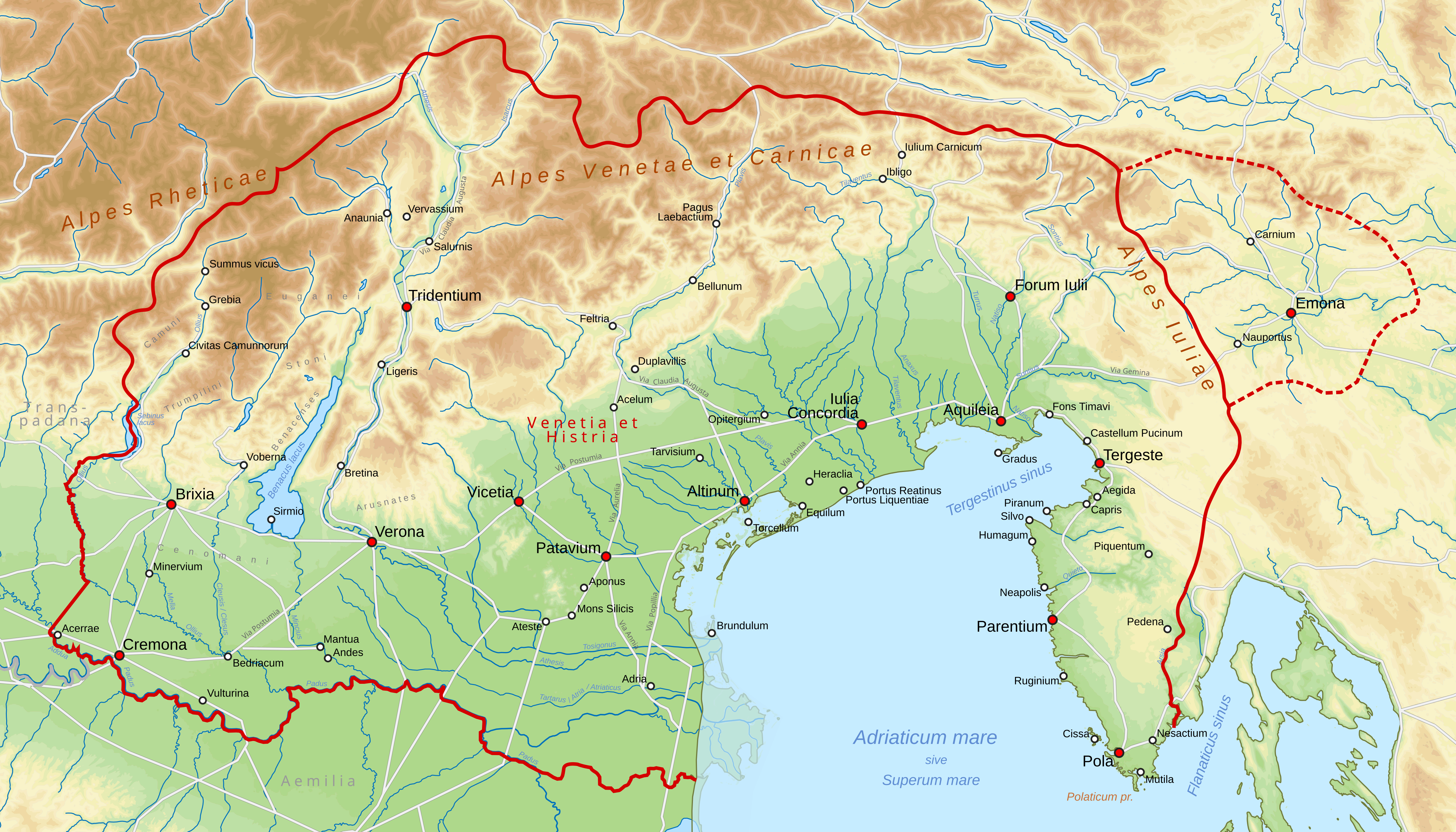
Origins and Strategic Location
Human presence at the site is recorded since the 10th century BC[3], but the process of Romanization intensified in the 2nd century BC with the foundation of Aquileia and the intersection of the Via Annia and Via Postumia.[4] In addition to the roads, the lagoon offered a healthy environment and safe harbors, as demonstrated by the defensive capabilities of the young Paduans against the Spartans described by Titus Livius.[5]
The ancient Iulia Concordia (today's Concordia Sagittaria) was a vital hub of Regio X in north-eastern Italy, situated at the intersection of wealthy trade routes linking the Italian peninsula to Central Europe and the Adriatic Sea. The region served as a transit point for Baltic amber coming from Slovenia[1] and for gold from the local mines described by Polybius.[2]
Foundation and Etymology
There is no certain date for its foundation, but the etymology provides valuable clues: Iulia references the imperial family, while Concordia indicates a political reconciliation. The main theories oscillate between the Caesarean era[6] and the period following the Second Triumvirate in 43 BC.[7] It is almost certain, however, that the city existed before 27 BC, as colonies founded after that date would have taken the epithet Augusta.[8]
Military Role and Decline
Over the centuries, the city witnessed the passage of imperial troops and barbarian invasions, such as those of the Quadi and Marcomanni, which led to the depopulation of the surrounding countryside.[9] In the 4th century AD, the city gained particular fame due to its arrow factory,[10] which was so significant that it gave the city its modern name, "Sagittaria."
Despite the economic vitality maintained until the beginning of the 5th century thanks to Eastern merchants, the barbarian invasions and the fall of the Western Roman Empire marked the inevitable decline of Concordia, following the fate of nearby Aquileia.
THE DISCOVERY OF THE NECROPOLIS
The First Unearthed Sarcophagi
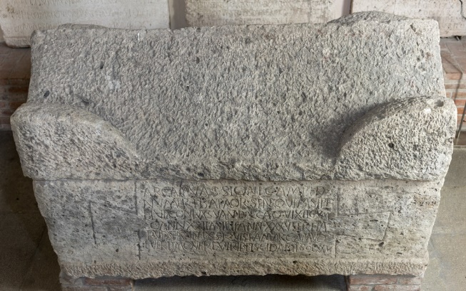
In February 1873, workers gathering sand at the left bank of the Lemene river discovered a sarcophagus that once belonged to the soldier Vassio in Count Perulli's estate.[11] By April, ten stone coffins had been unearthed, revealing a vast necropolis.[12] This discovery marked the culmination of Dario Bertolini's career, who played a central role throughout the excavation.[13]
Born in Portogruaro on 20 January 1823 as the third son of Giò Batta Bertolini from Caorle,[14] Bertolini studied at the Episcopal Seminary of Portogruaro, receiving a solid classical education.[15] Though he graduated in law in 1849, his keen interest in the ancient finds of nearby Concordia led him to pursue archaeology.[16]
Bertolini became the necropolis's most important promoter, reporting discoveries to local press and scientific journals including the Bullettino dell'Instituto di Corrispondenza Archeologica, where he continued publishing excavation updates.[17] Encouraged by De Rossi, director of the Bullettino di Archeologia Cristiana, Bertolini supervised the archaeological campaign,[18] receiving the official title of Honorary Inspector of Excavations and Monuments only in 1875.[19] This title was granted by Giuseppe Fiorelli, head of the Direzione centrale degli scavi e dei musei del Regno, an institution established that year to give the new Italian kingdom better control over regional archaeological sites.[20]
Excavations began when the city mayor convinced Count Perulli to temporarily concede his estate for a modest fee.[21] However, these lands comprised only the eastern section; Count Persico refused to concede his portion until it was finally excavated between 1890 and 1893.[22] Federico Berchet, member of the Commissione per la Conservazione dei Monumenti di Venezia, also supervised the excavation.[23]
The Excavation Works
The three main campaigns occurred between 1873 and 1875.[24] In 1876, engineer Antonio Bon created a necropolis map, though earthworks weren't completed until 1877 with the discovery of northwestern arches.[25] Throughout, Bertolini published discoveries in the Bullettino dell'Instituto di corrispondenza archeologica, Archivio Veneto, and from 1876, Notizie degli scavi di antichità.
By 1874, Bertolini had noticed an empty space north of the tombs, likely a road through the burial ground.[26] In 1875, this road was confirmed at nearly 2 meters depth, alongside brick tombs at the same level,[27] indicating they were older than the first tombs discovered just half a meter below the surface.[28] This revealed two main chronological phases separated by decades during which the Lemene River deposited sediment covering the road.[29] The second phase's terminus ante quem is clearer, dating to early 5th century based on Seleucid era inscriptions. For the terminus post quem, Brusin dated Firmina's sarcophagus to late 2nd century AD, notably early for burials so far from the urban center.[30]
A more cautious dating between 3rd and early 5th centuries AD is preferable. Discovered shrines and pagan statue heads suggest an earlier burial area with non-inhumation practices, though these finds had been reused and their provenance remains uncertain.[31]
Bertolini noted that deeper burials contained better-preserved skeletons, most found in very clear water filling the tombs, while coffin spaces were completely filled with clay or fine sand.[32] Puzzlingly, bodies placed higher—probably in anaerobic conditions due to clay—were worse preserved than those below. The crystal-clear water likely came from the aquifer and dispersed during excavation.
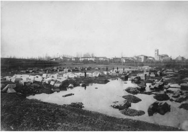
The Water Obstacle and the Abandonment of the Site
Underground water and the nearby river proved a significant obstacle,[33] slowing workers, damaging monuments, and creating unhealthy conditions that froze in winter and bred disease-carrying mosquitoes in summer.[34]
The operation ended in 1877 with 249 sarcophagi discovered—only about 70 with inscriptions—plus other funerary monuments and inscription fragments. Preservation proved difficult and expensive due to water.
In March 1877, a committee from the Commissione per la Conservazione dei Monumenti di Venezia revisited the site and reported the critical situation to the Direzione centrale.[35] Fiorelli consulted Mommsen, who responded on 31 October 1877.[36] Mommsen's radical yet necessary solution: create a 3D model of the necropolis and remove inscribed sarcophagus fronts before backfilling the site.[37]
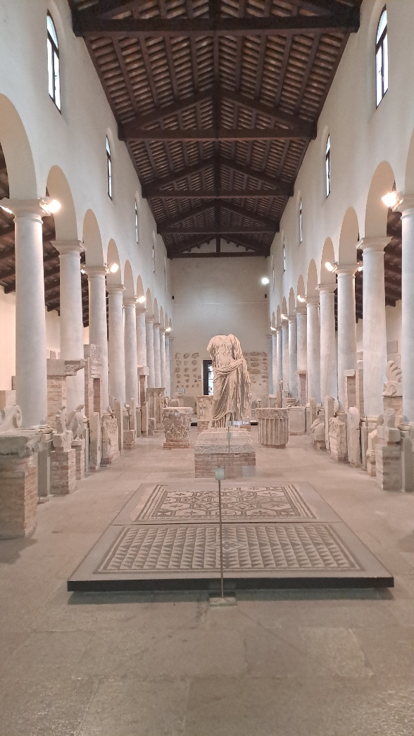
Museum construction began in 1885, designed by Bon to house the inscriptions, opening on 28 October 1888.[38] The Museo Concordiese di Portogruaro still preserves these artifacts today. The building resembles a three-nave church in the popular faux-Romanesque style of the period.[39]
Meanwhile, Count Perulli obtained rights to extract historically and artistically unimportant stones, while inscriptions were removed from sarcophagi and reburial operations began in 1890.[40]
The 3D model project suffered a worse fate. In 1879, Bon created a second planimetry as the model's basis, sent to Naples for creation by the same craftsmen who made Pompeii's model. However, crucial measurements like individual sarcophagus dimensions were missing. Since gathering this data in the waterlogged site proved too difficult and expensive, the project was abandoned and the 1879 plan disappeared.
The necropolis's abandonment represents an indelible loss for Iulia Concordia studies. Due to period limitations, water coverage, and the difficult attempt to save epigraphs, no complete archaeological study was conducted. Critical unpublished information now impossible to recover includes stratigraphic levels of each tomb (which would facilitate dating) and the loss or abandonment of remains. Though Bertolini occasionally mentioned skeletons,[41] they held little interest for the lawyer and his contemporaries, with no attempt to collect or preserve them. This reflected the era's lack of defined osteological practice, which would have enabled study of the deceased.
However, the recent discovery of Bon's 1879 plan in Naples's National Archaeological Museum archives represents a fundamental turning point.[42] Unlike the 1876 map, this marks sarcophagi discovered in 1877, with each arca bearing inscriptions signed with corresponding CIL edition numbers.[43]
Notes
- Šašel 1974, p. 147.
- Strab. 4.6.12.
- Bianchin Citton 2001, 102.
- Cresci Marrone 2001a, 119.
- Liv. 10.2.4-13.
- Scarpa Bonazza, Veronese 1978, 13.
- Zovatto 1973, 1.
- Scarpa Bonazza, Veronese 1978, 13.
- Croce Da Villa 2001b, 204.
- Cresci Marrone 2001b, 247.
- Zovatto 1965, 33; Vigoni 2022, 51; CIL V 8773 = EDR097921.
- Bertolini 1874a, 19.
- Vigoni 2016a, 211-249.
- Marzin 2004, 24.
- Marzin 2004, 24-27.
- Pettenò 2004, 138.
- Bertolini 1873a, 61.
- Pettenò 2004, 139.
- Pettenò 2004, 141.
- Vigoni 2022, 54.
- Pettenò 2004, 139-140.
- Lettich 1983, 17-18.
- Vigoni 2022, 53.
- Brusin, Zovatto 1960, 14.
- Vallicelli 2022, 79.
- Bertolini 1874b, 277.
- Bertolini 1875, 119-120.
- Bertolini 1874a, 19.
- Lettich 1983, 115-117.
- Brusin, Zovatto 1960, 59.
- Bertolini 1874a, 277-278.
- Bertolini 1875, 120.
- Pettenò 2004, 141-142; Vigoni 2022, 53.
- Brusin, Zovatto 1960, 14; Vigoni 2022, 55.
- Vigoni 2022, 55-56.
- Vigoni 2022, 56-57.
- ACS, Sc. e Mon. Ant., 1860-1890, B. 165, fasc. 341-7, 31/10/77.
- Pettenò 2004, 143-144.
- Zovatto 1965, 16.
- Vigoni 2022, 61-62.
- Bertolini 1873a, 59; Bertolini 1873b, 277; Bertolini 1874b, 36; Bertolini 1875, 119-120.
- Vallicelli 2022, 74.
- As-Mann VB4, 6.